
Consultation Updates
Following the first public exhibition on the 24th March and online interactive event on 26th March, we received feedback from the community.
Contents

The Site & Planning Context
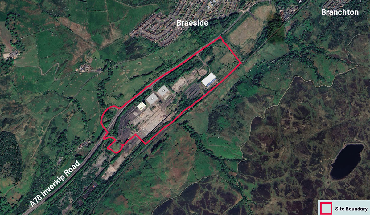
The site, known as ‘Spango Valley’, is located south of the A78 Inverkip Road in south west Greenock and is designated as a ‘Priority Place’ in the Inverclyde Local Development Plan (‘LDP’).
It is a large industrial brownfield site, having historically been a commercial / manufacturing facility for IBM since the 1950’s. Since 2017, when IBM closed, the site has been vacant with all the former buildings now demolished and the site cleared for redevelopment.
A planning application was submitted in 2020 (Ref: 20/0021/IC) for:
“Proposed mixed-use development comprising residential, industrial / business use, retail & leisure use and park & ride with associated roads infrastructure, access, open space, landscaping and drainage”.
This application was approved in March 2022, and then a subsequent planning application was approved in March 2023, which effectively increased the number of residential units approved to 450.
Market Conditions
Since this application was approved, the site owners have marketed the site for the consented uses (as above) but have not managed to secure a viable end user. As such, following receipt of Marketing Advice (from Savills), consideration has been given to alternative uses for the site to try and secure an end user and facilitate delivery of this long derelict brownfield site.
There has been strong interest from a data centre operator, and such a use is considered to be well suited to the site. This is due to growing demand (nationally) for this type of use, and the fact that the site is a large, flat area of land, making it ideally suited to a ‘large floorplate’ user. There are also distinct advantages in ‘co-locating’ the BESS to the data centre. The BESS will store energy generated elsewhere and supply it to the data centre whenever needed - in effect, storing surplus energy from the National Grid during off-peak hours and releasing this when demand is high. This helps ease pressure on the grid network and helps lower running costs.
Wider Site Proposal
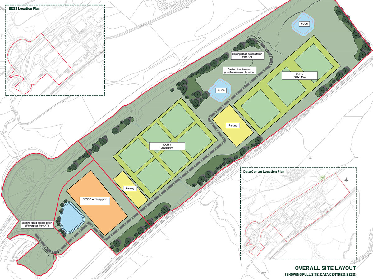
The applicant proposes the construction of a data centre, with associated development (i.e. access, roads, parking, landscaping and drainage). Also proposed is a BESS, with associated development.
The data centre application will be for Planning Permission in Principle (‘PPP’) which will be based on Indicative Drawings.
If consent is secured for PPP, a further submission for the Approval of Matters Specified in Conditions (‘AMSC’) will be required to confirm the detailed design of the proposed development, including building footprint, height and materials.
The BESS has been designed in detail although if approved, there would still be a number of conditions applied to the consent to secure the submission of a number of final details prior to construction starting.
The Applicant intends to seek PPP for the data centre, which, if approved, will establish the acceptability of the principle of development and key development parameters within the application site. This approach is intended to build in sufficient flexibility for the final design and layout to meet market requirements, but a key requirement will be for the PPP to confirm the following parameters:
- Overall floorspace quantum (sqm);
- Maximum height of the development / buildings;
- Key principles for site configuration, development areas, access etc; and
- Any required set backs from BESS / other receptors.
By using this approach, the chosen developer / ‘end user’ can come forward with their own detailed design to reflect the terms of any PPP consent granted.
What are Data Centres?
A data centre is a specialised facility that houses computer systems, storage devices, and networking infrastructure to store, manage, and process large amounts of digital data. They support the use of digital services like cloud computing / storage, online web streaming, and the use of current high memory usage software.
Data centres are therefore crucial to supporting the digital economy and everyday digital services.
The Scottish Government aims to position Scotland as a hub for green data centres, recognising their strategic role in the digital economy and potential for regional economic development. The 2021 Green Datacentres and Digital Connectivity Vision and Action Plan outlines plans to grow clusters of low-carbon, energy-efficient facilities powered primarily by renewable sources.
In addition, the Scottish Government report ‘How Scotland will Thrive in a Digital World (2021)’ confirms there are aspirations to establish Scotland as an attractive location for green data centres.
However, it is recognised that the need to attract investment in digital infrastructure needs to be balanced with environmental and planning considerations, with the aim to foster sustainable and energy efficient data centre development across the country.
Although the layout is indicative, it is anticipated that the data centre will include:
- Data Centre Buildings
- Access / Roads / Hardstanding
- Drainage (SuDS)
- Parking
- Control & Welfare Rooms
- Security Fencing
- Landscaping

What is a Battery Energy Storage System (BESS)?
BESS facilitates the storage and release of energy generated from renewables, such as wind and solar farms. Batteries of varying scale are an ideal technology to support the increasing dependency on low carbon technology in the UK’s energy generation mix and facilitate the stability of the network as balancing supply and demand. National Grid highlights energy storage as a key growth area and estimates that as much as 30GW of installed capacity could be required by 2050.
BESS has a key part to play in ensuring homes and businesses can be powered by low carbon energy, even when the sun is not shining or the wind is not blowing. For example, the UK has the largest installed capacity of offshore wind in the world, but the value of clean energy can be increased by improving the ability to capture this energy and purposefully deploy when it’s needed, increasing production, improving efficiency, and potentially reducing costs.
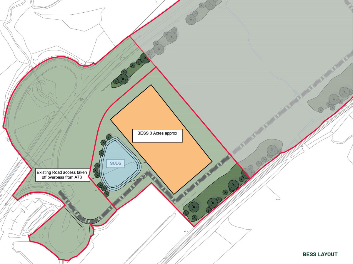
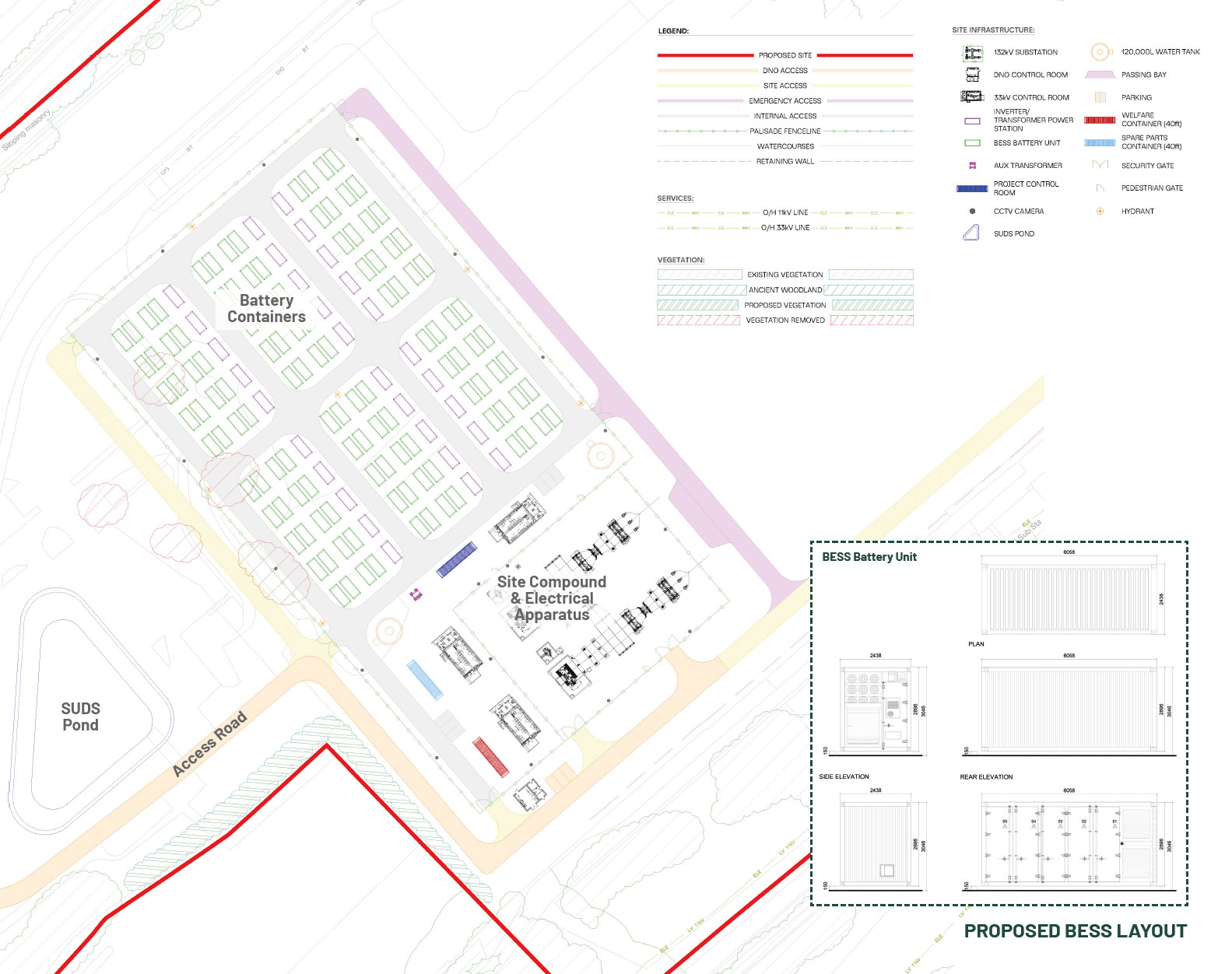
Proposed BESS Layout
The site currently forms part of a wider allocated development site ‘Spango Valley’, which is identified within the adopted LDP as a ‘Priority Place’. This seeks to promote the site for a mix of uses, including residential, industrial and business and a mix of supporting uses such as neighbourhood retail, leisure and recreation or appropriate renewable energy uses.
Whilst consent is in place for a residential-led mixed-use development, as detailed earlier the owners have marketed the site for these approved uses but have been unsuccessful in securing a viable end user. As such, consideration has been given to other land uses which would also be appropriate for the site.
The extant Development Plan for the site comprises the Inverclyde LDP and National Planning Framework 4 (‘NPF4’).
NPF4
NPF4 provides broad support for BESS, with Policy 11 (a) stating that development proposals for all forms of renewable, low-carbon and zero emissions technologies will be supported. These include (iii.) energy storage, such as battery storage. The document also notes that there are significant opportunities for investment in heat networks, energy storage and the circular economy to create more sustainable neighbourhoods.
In terms of data centres, NPF4 confirms that Major developments for green data centres are designated as National developments, giving them support at the ‘top tier’ of planning policy. Although NPF4 provides no definition for a ‘green data centre’ it is considered to be a data centre that uses energy-efficient technologies to optimise energy use and minimise environmental impact.
LDP
In terms of BESS, Policy 4 confirms that proposals for infrastructure for the generation, storage or distribution of heat and electricity will be supported in principle where they contribute to a reduction in greenhouse gas production.
The LDP has no specific polices for data centre development, but it is noted that Schedule 2 (Spango Valley) confirms that the preferred strategy includes mixed use development including business, industrial, storage or distribution.
A full assessment of both proposals against relevant energy and planning policy will be included within ‘Planning Statements’ which will accompany each application however in light of the above summary, it is considered that the proposed uses are broadly compliant with policy.
Consent will be sought for a BESS, with a capacity of c.99MW. Although the proposals are yet to be finalised, it is anticipated to include:
- BESS Battery Units;
- 132kV Substation;
- DNO Control Room;
- 33kV Control Room;
- Inverter / Transformer Power Station;
- Aux Transformer;
- Control Room;
- Welfare & Spare Parts Container;
- CCTV Cameras;
- Security & Pedestrian Gates / Fencing;
- Water Tank (120,000L);
- SuDS Pond;
- Access & Parking; and
- Landscaping.
Planning Considerations
Site Assessment & Environmental Considerations
The previous application for the site included a full Environmental Impact Assessment (EIA), meaning that the Applicant already has a robust understanding of the suitability of the site for development in relation to a wide range of matters including access & transport, landscape & visual impact, noise, air quality, cultural heritage, drainage, flood risk, trees/arboriculture, ecology and ground conditions.
Noting the proposed change of land use, and time which has passed since these previous reports for the site were undertaken, updated reports are being prepared, and these will be included in the applications, when submitted.
However, an initial summary for each topic is set out below:
Access
Developments of this nature typically generate low numbers of traffic movements throughout the day. This will be confirmed through the technical exercise currently being undertaken, which includes engagement with officers from Inverclyde Council and Transport Scotland, and a review of the current traffic conditions and transport infrastructure. This exercise will culminate in a comprehensive Transport Assessment that will be submitted with both applications (for the BESS and data centre). This report will set-out the access arrangements from the A78, along with measures to support sustainable modes of transport.
Ecology & Biodiversity
Baseline ecological surveys are currently being conducted to inform the project, inclusive of a Preliminary Ecological Appraisal (PEA) which comprises baseline habitat and protected species surveys. The findings of the PEA will inform further targeted ecological assessments and aid in the site design layout and future mitigation and enhancement.
Noise
A Noise Impact Assessment is being undertaken to consider potential effects from the Data Centre (and BESS) at any nearby residential properties with potential for noise impacts. The assessment shall include noise monitoring of existing background levels during both day-time and night-time periods. Predicted noise emissions from the data centre and BESS shall be assessed against the measured background levels in accordance with BS 4142. Noise mitigation advice shall be provided as appropriate to minimise any potential for noise impact from the developments. A full technical Noise Assessment will accompany both applications.
Air Quality
An Air Quality Screening Assessment is being undertaken to consider potential air quality effects from the proposed developments. The assessment will review potential impacts on nearby sensitive receptors, primarily in relation to emissions from traffic on the surrounding road network, in accordance with relevant guidance and Scottish air quality policy. An initial review indicates that, given the nature of the proposals and absence of significant emission sources, predicted air quality impacts are expected to remain within relevant guideline thresholds. An Air Quality screening letter report will be submitted with both applications to detail the findings of the assessment.
Landscape & Visual
A Landscape and Visual Appraisal (LVA) is being undertaken in line with the principles of best practice guidance (GLVIA3 - Guidelines for Landscape and Visual Impact Assessment, 3rd Edition (2013) Landscape Institute and the Institute for Environmental Management and Assessment). Supported by annotated photographs and appropriate plans and figures, including a computer-generated Screened Zone of Theoretical Visibility (SZTV).
Flood Risk
A Flood Risk Assessment is a planning requirement to ensure that the proposed development is not at risk of flooding and does not increase flood risk elsewhere and to ensure that the proposed development is compliant with the National Planning Framework 4 (NPF4, 2023) Policy 22. This highlights that no building is permitted within an area at flood risk arising from a 1 in 200 year event (inclusive of climate change). This will be submitted with both applications to meet the requirements of policy and guidance.
Drainage
A Drainage Impact Assessment is currently being undertaken to identify the appropriate sustainable drainage system (SuDS) solution to manage flood risk and provide appropriate water quality treatment and attenuation of site runoff prior to discharge. The most likely SuDS options include filter drains through the site, to convey the water from the site roofs and hardstanding and provide a first level of treatment, followed by attenuation and further treatment within a SuDS detention basin. The SuDS will be designed and sized to satisfy regulatory requirements and ensure no detrimental flood risk impact from discharge of surface water from the site to the Spango Burn. A finalised SuDS approach will be prepared to accompany the applications.
Trees & Arboriculture
Arboricultural surveys will be undertaken to inform the proposed development. These include detailed tree quality assessments in accordance with BS 5837:2012 ‘Trees in relation to design, demolition, and construction – Recommendations’. The Tree Survey Report will document the condition, quality, and constraints of all surveyed trees, including their physiological and structural status, categorisation in line with BS 5837, and associated Root Protection Area (RPA) constraints. This information will be used to inform the development layout to ensure the retention and appropriate protection of higher value trees where feasible. An Arboricultural Impact Assessment (AIA) and Tree Protection Plan (TPP), supported by the BS 5837 tree survey data and finalised site layout, will be submitted alongside the applications.
Services & Utilities
Given the brownfield nature of the site, and its previous uses, it is well served by existing utility connections and there are no concerns over servicing the site for the proposed use.
What Happens Next?
Supporting Reports
Following completion of all technical work detailed above, it is anticipated that the applications will be accompanied by the below information. Separate reports will be prepared for each application, in the interest of transparency.
| Document | Author |
|---|---|
| Planning Statement | Pegasus Group |
| Design & Access Statement | Pegasus Group |
| Pre-Application Consultation Report | Pegasus Group |
| Landscape & Visual Appraisal | Pegasus Group |
| Transport Assessment | SYSTRA |
| Preliminary Ecological Appraisal | EnviroCentre |
| Biodiversity Enhancement Plan | EnviroCentre |
| Noise Impact Assessment | EnviroCentre |
| Tree Survey & Arboricultural Impact Assessment | EnviroCentre |
| Flood Risk Assessment | EnviroCentre |
| Drainage Impact Assessment | EnviroCentre |
| Air Quality Assessment | EnviroCentre |
Project Timeline
27th February 2026Submission of Proposal of Application Notice
24th March 2026Public Exhibition 1
26th March 2026Online Live Chat 1
23rd April 2026Public Exhibition 2
28th April 2026Online Live Chat 2
On this websiteJune 2026Submission of Planning Application
November 2026Target Determination of planning application